Posts

Former Typhoon Merbok Blasts Alaska With Historic Storm Surge

A historic storm blasted western Alaska Friday and Saturday with hurricane-force winds, over 50-foot seas and coastal flooding not seen in decades, leaving homes flooded, roads washed away and power out to a wide area.

What used to be Typhoon Merbok morphed into a powerful northern Pacific storm as it raced nearly due north and pushed through the Aleutian Islands Friday and into the Bering Sea Saturday, bringing a dangerous storm surge inundating coastal villages and towns under several feet of water for hours.

Alaska Gov. Mike Dunleavy declared a state disaster area Saturday morning and was set to ask the U.S. government for a federal disaster declaration on Monday. But Dunleavy says despite the record-breaking impacts, the emergency operation center had not received any reports of injuries.

As the storm weakened and passed into the Arctic, towns and villages along the Bering Sea began cleaning up debris that had washed ashore. Dozens of homes and buildings flooded as the Bering Sea pushed inland, and several roads left damaged.

(Read more from “Former Typhoon Merbok Blasts Alaska With Historic Storm Surge” HERE)

Delete Facebook, Delete Twitter, Follow Restoring Liberty and Joe Miller at gab HERE.

Experts Warn of ‘Life-Threatening’ Storm Surge Along Gulf Coast

Tropical Storm Gordon is strengthening and should hit the central U.S. Gulf Coast as a hurricane late Tuesday before moving over the lower Mississippi Valley on Wednesday.

Gordon formed into a tropical storm near the Florida Keys early Monday, lashing the southern part of the state with heavy rains and high winds.

By early Tuesday morning, the storm was centered 230 miles east-southeast of the mouth of the Mississippi River, with top sustained winds of 65 mph, forecasters said. It was moving relatively quickly, at about 17 mph.

A hurricane warning was put into effect for the mouth of the Pearl River in Mississippi to the Alabama-Florida border. As much as 8 inches of rain could fall in some parts of the Gulf states through late Thursday.

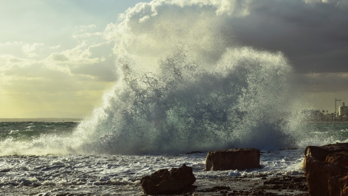
The Miami-based National Hurricane Center is predicting a “life-threatening” storm surge along parts of the central Gulf Coast. A storm surge warning has been issued for the area stretching from Shell Beach, Louisiana to Dauphin Island, Alabama. The warning means there is danger of life-threatening inundation. The region could see rising waters of 3 to 5 feet.

“The deepest water will occur along the immediate coast near, and to the east of, the landfall location, where the surge will be accompanied by large waves,” the center said.

Louisiana Gov. John Bel Edwards declared a state of emergency Monday and said 200 National Guard troops will be deployed to southeastern Louisiana.

The storm’s predicted track had shifted slightly east as of Monday evening, meaning Louisiana is currently just outside the area under the hurricane warning. Still, the southeastern part of the state remains under a tropical storm warning and residents need to be prepared for the storm to shift west, Edwards said.

“This storm has every possibility to track further in our direction,” Edwards said during a news conference Monday evening.

New Orleans Mayor LaToya Cantrell said the city has “the pumps and the power” needed to protect residents. But authorities issued a voluntary evacuation order for areas outside the city’s levee protection system, including the Venetian Isles, Lake Saint Catherine and Irish Bayou areas.

Cantrell urged residents within the levee protection area to stock up on supplies and shelter in place.

Miami Beach Police said via Twitter that the Labor Day holiday was “NOT a beach day,” with rough surf and potential rip currents. Red flags flew over Pensacola-area beaches in Florida’s Panhandle, where swimming and wading in the Gulf of Mexico was prohibited.

More than 4,000 Florida Power & Light customers lost power Monday due to weather conditions.

The National Weather Service said conditions were “possible” for tornadoes in the affected parts of South Florida on Monday night.

The storm left many businesses on Florida’s Gulf Coast feeling shortchanged by the holiday weekend. The area has already been heavily impacted by this summer’s so-called “red tide” — massive algae blooms that have caused waves of dead marine life to wash up along the coast.

Jenna Wright, owner of a coffee shop in Naples, Florida, told the Naples Daily News that she had expected higher numbers for the Labor Day weekend.

“This is normally a decent weekend, but the storm and red tide aren’t helping,” Wright said. “We’re a beach coffee shop, and if people can’t go to the beach, then we won’t get any customers.”

Separately, Tropical Storm Florence continues to hold steady over the eastern Atlantic. Forecasters say little change in strength is expected in coming days and no coastal watches or warnings are in effect. (For more from the author of “Experts Warn of ‘Life-Threatening’ Storm Surge Along Gulf Coast” please click HERE)

Follow Joe Miller on Twitter HERE and Facebook HERE.

Southeast Socked by Rare Snowstorm Ahead of ‘Bomb Cyclone’ Forecast to Hit Northeast

By Nicole Darrah. Much of the southeastern U.S. was slammed by a brutal winter storm Wednesday, with Florida, Georgia and South Carolina seeing a rare blast of snow and sleet — the worst snowstorm to hit some cities in decades.

Forecasters have warned the same weather system could soon strengthen into a “bomb cyclone” as it continues to travel north on the East Coast. The storm could “produce strong, damaging winds — possibly resulting in downed trees, power outages and coastal flooding,” according to the National Weather Service (NWS).

At least 17 deaths have been blamed on dangerously cold temperatures that for days have gripped widespread areas of the U.S. from Texas to New England.

Floridians in Tallahassee saw snow for the first time in 28 years.

The National Weather Service on Wednesday recorded 5 inches of snow and significant accumulations of ice in Charleston, South Carolina. Across the Georgia-South Carolina state line, the weather service reported 1.2 inches of snowfall in Savannah. (Read more from “Southeast Socked by Rare Snowstorm Ahead of ‘Bomb Cyclone’ Forecast to Hit Northeast” HERE)

________________________________________

Winter Storm Threatens East Coast, Bringing Temps Colder Than Mars

By CNN. A massive “bombogenesis” — an area of rapidly declining low pressure — will wreak havoc on the Northeast this week, threatening hurricane-force winter wind gusts and blinding snow.

The bombogenesis will result in what’s known as a “bomb cyclone.” And the bomb cyclone, expected to strike Thursday, will likely dump 6 to 12 inches of snow in New England and hurl 40- to 60-mph gusts.

By the end of this week, parts of the Northeast will be colder than Mars.

The impending storm led to more than 2,700 preemptive US flight cancellations for Thursday, according to Flightaware.com. (Read more from “Winter Storm Threatens East Coast, Bringing Temps Colder Than Mars” HERE)

Follow Joe Miller on Twitter HERE and Facebook HERE.

Hurricane Threatens the Gulf Coast With a Biblical Flood Disaster

It’s the tropical storms you think are dead but come back to life that you need to be truly afraid of.

One such storm, soon to intensify into Tropical Storm Harvey, is poised to pick up copious amounts of moisture from the bathtub warm waters of the Gulf of Mexico, before making a slow-speed collision with the low-lying Texas coast this weekend.

Like the meteorological equivalent of a White Walker from Game of Thrones, Harvey had previously been a named storm that dissipated as it crossed Mexico’s Yucatan Peninsula earlier this week.

The storm has the potential to drop colossal amounts of rain from Corpus Christi, Texas to Lafayette, Louisiana, with the flood-prone city of Houston in the middle of the threat zone.

Rainfall totals could exceed 20 or even 30 inches in some places, since the storm is expected to meander along the Texas coast once it makes landfall, moving less than 500 miles from Friday through Monday morning. (Read more from “Hurricane Threatens the Gulf Coast With a Biblical Flood Disaster” HERE)

Follow Joe Miller on Twitter HERE and Facebook HERE.

Rare Tropical System Forms Over Atlantic Ocean

Subtropical Storm Alex has formed in the Atlantic Ocean, making it one of the earliest tropical systems to form in the Atlantic Hurricane Basin since records began in 1851 . . .

Alex is located well in the eastern Atlantic Ocean and doesn’t pose a threat to the United States; however, it will affect the Azores. According to Kottlowski, Alex will bring gale-force winds and several inches of heavy rain to the Azores.

Alex is the first tropical system to form over the Atlantic Ocean in January since Subtropical Storm One in 1978. The earliest tropical storm to form in January was Storm One on Jan. 3, 1939. (Read more from “Rare Tropical System Forms Over Atlantic Ocean” HERE)

Follow Joe Miller on Twitter HERE and Facebook HERE.

Star of Discovery’s ‘Storm Chasers’ Show Among Dead in Oklahoma Tornado

Photo Credit: Discovery Channel

A star of the Discovery Channel show “Storm Chasers,” his son and a colleague have been identified as three of the 13 people killed after an outbreak of tornadoes struck the Oklahoma City area on Friday.

Tim Samaras, 55, died with his son Paul, 24, and friend Carl Young, 45, in Canadian County chasing down a tornado that wreaked havoc along Interstate 40, Fox 25 reports.

“We are deeply saddened by the loss of Tim Samaras his son Paul and their colleague Carl Young,” the Discovery Channel said in a statement to FOX411. “Our thoughts and prayers go out to their families.”

The channel added that it would be dedicating Sunday night’s show on the tornadoes in their memory.

Read more from this story HERE.

Hill Hearing On Global Warming Cancelled By D.C. Snowstorm

Photo Credit: APAn unusually chilly March day and the snowstorm it spawned have shut down much of official Washington on Wednesday — including a hearing House Republicans had called to examine global warming.

“Postponed due to weather,” read the notice from the House Science, Space and Technology Committee sent in the morning.

The hearing was scheduled to give House lawmakers a comprehensive briefing on how well scientists understand the climate and humans’ effects on it as a means “to inform decision-making on potential mitigation options.”

Read more from this story HERE.

Rare Alaska Storm Packing 100mph Winds Takes Out Power to Half of Anchorage

An overnight wind storm with gusts of over 100 miles an hour at high elevations knocked out power to at least half of Alaska’s largest city in the biggest outage in Anchorage’s center in decades, municipal and utility officials said on Wednesday.

“It’s incredibly substantial. A huge proportion of Anchorage is affected,” said Dawn Brantley, emergency program manager for the Municipality of Anchorage.

She said she did not know yet what percentage of the city overall had been affected but called the outage the biggest for downtown Anchorage in decades.

Electricity was cut to at least half of Anchorage, including nearly all customers of the utility that serves the central part of the city, the officials said.

Tens of thousands of homes and businesses remained without power by midday on Wednesday, Brantley said.

Read more from this story HERE.